
A cenote is a sinkhole with exposed rocky edges containing groundwater. It is typically found in the Yucatán Peninsula and some nearby Caribbean islands. The term is derived from a word used by the low-land Yucatec Maya to refer to any location where groundwater is accessible.
According to Anatoly Beloshchin, a professional photographer, the underwater scenery is amazing. He describes, “We are 30 meters deep, fresh water, then 60 meters deep – salty water and under me I see a river, island and fallen leaves… Actually, the river, which you can see, is a layer of hydrogen sulphide."
The river illusion is due to a phenomenon called halocline, a cline caused by a strong, vertical salinity gradient within a body of water. Because salinity (in concert with temperature) affects the density of seawater, it can play a role in its vertical stratification. Increasing salinity by one kg/m3 results in an increase of seawater density of around 0.7 kg/m.
The Yucatan Peninsula contains a vast coastal aquifer system which is typically density-stratified. The infiltrating meteoric water (i.e., rainwater) floats on top of higher density saline water intruding from the coastal margins. The whole aquifer is therefore an anchialine system (i.e., one that is land-locked, but connected to an ocean). Where a cenote, or the flooded cave it is an opening to, provides deep enough access into the aquifer then the interface between the fresh and saline water may be reached. The density interface between the fresh and saline waters is a halocline, which means a sharp change in salt concentration over a small change in depth. Mixing of the fresh and saline water results in a blurry swirling effect due to refraction between the different density fresh and saline waters. The depth of the halocline is a function of several factors: climate and specifically how much meteoric water recharges the aquifer, hydraulic conductivity of the host rock, distribution and connectivity of existing cave systems and how effective these are at draining water to the coast, and the distance from the coast. In general, the halocline is deeper the further from the coast and in the Yucatan Peninsula this depth is 10 to 20 meters below the water table at the coast, and 50 to 100 meters below the water table in the middle of the peninsula, with saline water underlying the whole of the peninsula.
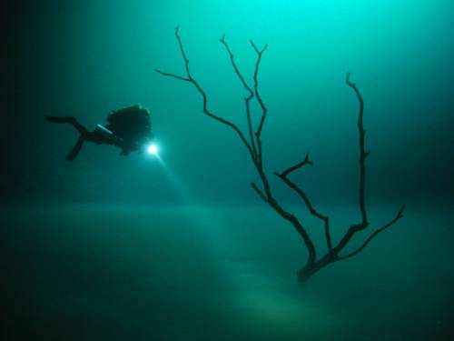
In Cenote Angelita as you get deeper the water turns from pure to salty; 30 meters deep the water is pure, 60 meters deep it becomes saline. Some meters before you get to the bottom of the cave, you see a river underneath, with trees and leaves floating on some liquid level. However it may seem like a river, it’s not a real river. It’s just a layer of hydrogen sulphide.
According to Anatoly Beloshchin, a professional photographer, the underwater scenery is amazing. He describes, “We are 30 meters deep, fresh water, then 60 meters deep – salty water and under me I see a river, island and fallen leaves… Actually, the river, which you can see, is a layer of hydrogen sulphide."
The river illusion is due to a phenomenon called halocline, a cline caused by a strong, vertical salinity gradient within a body of water. Because salinity (in concert with temperature) affects the density of seawater, it can play a role in its vertical stratification. Increasing salinity by one kg/m3 results in an increase of seawater density of around 0.7 kg/m.
The Yucatan Peninsula contains a vast coastal aquifer system which is typically density-stratified. The infiltrating meteoric water (i.e., rainwater) floats on top of higher density saline water intruding from the coastal margins. The whole aquifer is therefore an anchialine system (i.e., one that is land-locked, but connected to an ocean). Where a cenote, or the flooded cave it is an opening to, provides deep enough access into the aquifer then the interface between the fresh and saline water may be reached. The density interface between the fresh and saline waters is a halocline, which means a sharp change in salt concentration over a small change in depth. Mixing of the fresh and saline water results in a blurry swirling effect due to refraction between the different density fresh and saline waters. The depth of the halocline is a function of several factors: climate and specifically how much meteoric water recharges the aquifer, hydraulic conductivity of the host rock, distribution and connectivity of existing cave systems and how effective these are at draining water to the coast, and the distance from the coast. In general, the halocline is deeper the further from the coast and in the Yucatan Peninsula this depth is 10 to 20 meters below the water table at the coast, and 50 to 100 meters below the water table in the middle of the peninsula, with saline water underlying the whole of the peninsula.
In Cenote Angelita as you get deeper the water turns from pure to salty; 30 meters deep the water is pure, 60 meters deep it becomes saline. Some meters before you get to the bottom of the cave, you see a river underneath, with trees and leaves floating on some liquid level. However it may seem like a river, it’s not a real river. It’s just a layer of hydrogen sulphide.
No comments:
Post a Comment