Goodwin Sands
The Goodwin Sands are a 10-mile-long sand bank in the English Channel, lying six miles east of Deal in Kent, England. The Brake Bank lying shorewards is part of the same geological unit. As the shoals lie close to major shipping channels, more than 2,000 ships are believed to have been wrecked upon them, and as a result they are marked by lightvessels and buoys. Notable shipwrecks include the VOC ship Rooswijk, HMS Stirling Castle, the SS Montrose and the South Goodwin Lightship'. Several naval battles have been fought nearby, including the Battle of Goodwin Sands in 1652 and the Battle of Dover Strait in 1917.
There is currently a lightship on the end of the sands, on the farthest part out, to warn ships. The sands were once covered by two lighthouses on the Kent mainland, one each at the north and south ends of the sands. The southern lighthouse is now owned by the National Trust, and the northern one is still in operation.
Bermuda Triangle
The Bermuda Triangle, also known as the Devil's Triangle, is a region in the western part of the North Atlantic Ocean where a number of aircraft and surface vessels allegedly disappeared mysteriously. Popular culture has attributed these disappearances to the paranormal or activity by extraterrestrial beings. Documented evidence indicates that a significant percentage of the incidents were inaccurately reported or embellished by later authors, and numerous official agencies have stated that the number and nature of disappearances in the region is similar to that in any other area of ocean.
The boundaries of the triangle cover the Straits of Florida, the Bahamas and the entire Caribbean island area and the Atlantic east to the Azores. The more familiar triangular boundary in most written works has as its points somewhere on the Atlantic coast of Miami, San Juan, Puerto Rico; and the mid-Atlantic island of Bermuda, with most of the accidents concentrated along the southern boundary around the Bahamas and the Florida Straits.
The area is one of the most heavily traveled shipping lanes in the world, with ships crossing through it daily for ports in the Americas, Europe, and the Caribbean Islands. Cruise ships are also plentiful, and pleasure craft regularly go back and forth between Florida and the islands. It is also a heavily flown route for commercial and private aircraft heading towards Florida, the Caribbean, and South America from points north.
Pacific Munitions Dump
Chemical weapons dumped in deep water five miles south of Pearl Harbor after World War II should remain at the site because moving them could pose more of a threat to people and the environment, the Army said Friday.
Records show the Army dumped 16,000 bombs at the site after the war; each of the bombs contained 73 pounds of the chemical agent mustard.
The spots where the military has dumped chemical weapons off Hawaii are too deep to normally be reached by the public. They're also marked on nautical charts and ships do not trawl in these areas.
The military's Explosives Safety Board believes the safest approach to underwater munitions is to leave them in place and to educate the public about what they should do when they find a shell. However, the board believes weapons that pose an imminent and substantial danger should be removed.
The military used the ocean as a dumping ground for munitions between 1919 and 1970.
Related Articles :
Great Pacific Garbage Patch
Northwest Passage
The Northwest Passage is a sea route through the Arctic Ocean, along the northern coast of North America via waterways amidst the Canadian Arctic Archipelago, connecting the Atlantic and Pacific Oceans. The various islands of the archipelago are separated from one another and the Canadian mainland by a series of Arctic waterways collectively known as the Northwest Passages or Northwestern Passages.
Sought by explorers for centuries as a possible trade route, it was first navigated by Roald Amundsen in 1903–1906. Until 2009, the Arctic pack ice prevented regular marine shipping throughout most of the year, but climate change has reduced the pack ice, and this Arctic shrinkage made the waterways more navigable. However, the contested sovereignty claims over the waters may complicate future shipping through the region: The Canadian government considers the Northwestern Passages part of Canadian Internal Waters, but various countries maintain they are an international strait or transit passage, allowing free and unencumbered passage.
There has been speculation that with the advent of global warming the passage may become clear enough of ice to again permit safe commercial shipping for at least part of the year. On August 21, 2007, the Northwest Passage became open to ships without the need of an icebreaker. According to Nalan Koc of the Norwegian Polar Institute this is the first time it has been clear since they began keeping records in 1972. The Northwest Passage opened again on August 25, 2008.
Thawing ocean or melting ice simultaneously opened up the Northwest Passage and the Northern Sea Route (Northeast Passage), making it possible to sail around the Arctic ice cap. Compared to 1979, Daily Mail published "Blocked: The Arctic ice, showing as a pink mass in the 1979 picture, links up with northern Canada and Russia." Awaited by shipping companies, this 'historic event' will cut thousands of miles off their routes. Warning, however, that the NASA satellite images indicated the Arctic may have entered a "death spiral" caused by global warming, Professor Mark Serreze, a sea ice specialist at National Snow and Ice Data Center (NSIDC), USA, said: "The passages are open. It's a historic event. We are going to see this more and more as the years go by." Due to Arctic shrinkage, the Beluga group of Bremen, Germany, announced plans to send the first ship through the Northern Sea Route in 2009, which may shorten the trip from Germany to Japan by 4,000 nautical miles (7,400 km; 4,600 mi). However, Canada's Prime Minister Stephen Harper announced that "ships entering the North-West passage should first report to his government."
The Seven Seas
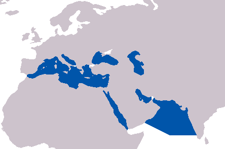
The phrase "Seven Seas" (as in the idiom "sail the Seven Seas") can refer either to a particular set of seven seas or to a great expanse of water in general. People from different time periods have meant different things by the phrase "Seven Seas".
In Medieval European literature, the Seven Seas referred to the following seas: the Mediterranean Sea, the Adriatic Sea, the Black Sea, the Red Sea, the Arabian Sea, the Persian Gulf, and the Caspian Sea.
Today however, the International Hydrographic Organization lists over 100 bodies of water known as seas.