Arctic Circle
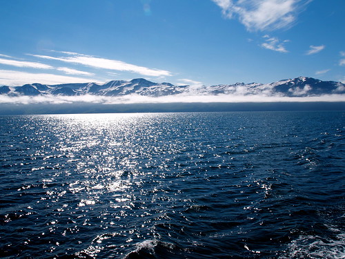
The Arctic Circle is one of the five major circles of latitude that mark maps of the Earth. For Epoch 2011, it is the parallel of latitude that runs 66° 33′ 44″ (or 66.5622°) north of the Equator.
The region north of this circle is known as the Arctic, and the zone just to the south is called the Northern Temperate Zone. The equivalent polar circle in the Southern Hemisphere is called the Antarctic Circle.
The Arctic Circle marks the southern extremity of the polar day (24-hour sunlit day, often referred to as the "midnight sun") and polar night (24-hour sunless night). North of the Arctic Circle, the sun is above the horizon for 24 continuous hours at least once per year and below the horizon for 24 continuous hours at least once per year. On the Arctic Circle those events occur, in principle, exactly once per year, at the June and December solstices, respectively.
In fact, because of atmospheric refraction and because the sun appears as a disk and not a point, part of the midnight sun may be seen on the night of the northern summer solstice up to about 50′ (90 km (56 mi)) south of the Arctic Circle; similarly, on the day of the northern winter solstice, part of the sun may be seen up to about 50′ north of the Arctic Circle. That is true at sea level; those limits increase with elevation above sea level although in mountainous regions, there is often no direct view of the horizon.
The position of the Arctic Circle is not fixed, but directly depends on the Earth's axial tilt, which fluctuates within a margin of 2° over a 40,000 year period, notably due to tidal forces resulting from the orbit of the Moon. The Arctic Circle is currently drifting northwards at a speed of about 15 m (49 ft) per year.
Relatively few people live north of the Arctic Circle due to the Arctic climate. The three largest communities above the Arctic Circle are situated in Russia: Murmansk (population 325,100), Norilsk (135,000), and Vorkuta (85,000). Tromsø (in Norway) has about 62,000 inhabitants. In contrast, the largest North American community north of the circle, Barrow, Alaska, has approximately 4,000 inhabitants. Rovaniemi (in Finland), which lies slightly south of the line, has a population of approximately 58,000, and is the largest settlement in the immediate vicinity of the Arctic Circle.
False Catshark
The false catshark (Pseudotriakis microdon) is a species of ground shark in the family Pseudotriakidae, and the sole member of its genus. It has been reported from a number of locations worldwide, usually at depths of 200-1,500 meters (660-4,900 ft) on the continental slopes. A large, slow-moving shark, it feeds mostly on bony fishes but also takes elasmobranchs and cephalopods, and scavenges off the sea floor. It is one of the few non-lamnoid sharks known to exhibit intrauterine oophagy, in which the developing embryos feed on eggs ovulated by the mother. This species is of minimal interest to fisheries.
The Pacific populations of the false catshark were formerly regarded as a separate species, Pseudotriakis acrales; Leonard Compagno synonymized the two species in 1984 based on a lack of distinguishing characteristics. The closest living relative of the false catshark is the slender smooth-hound (Gollum attenuatus), and some authors place that species in the Pseudotriakidae.
The false catshark is known from scattered locations worldwide, including New York, New Jersey, Cuba, Brazil, Iceland, France, Portugal, Madeira, the Azores, Senegal, Cape Verde, the Aldabra Islands, Japan, Taiwan, Australia, New Zealand, and Hawaii. It is found near the bottom on continental and insular slopes from 173 to 1,890 meters (570-6,100 ft), but occasionally wanders over the continental shelf into shallower water.
Deepwater Horizon Oil Spill
The Deepwater Horizon oil spill is an oil spill in the Gulf of Mexico which flowed for three months in 2010. The impact of the spill continues even after the well has been capped. It is the largest accidental marine oil spill in the history of the petroleum industry. The spill stemmed from a sea-floor oil gusher that resulted from the April 20, 2010 explosion of Deepwater Horizon, which drilled on the BP-operated Macondo Prospect. The explosion killed 11 men working on the platform and injured 17 others. On July 15, the leak was stopped by capping the gushing wellhead, after it had released about 4.9 million barrels (780×103 m3), or 205.8 million gallons of crude oil. It was estimated that 53,000 barrels per day (8,400 m3/d) were escaping from the well just before it was capped. It is believed that the daily flow rate diminished over time, starting at about 62,000 barrels per day (9,900 m3/d) and decreasing as the reservoir of hydrocarbons feeding the gusher was gradually depleted. On September 19, the relief well process was successfully completed, and the federal government declared the well "effectively dead."
The spill caused extensive damage to marine and wildlife habitats as well as the Gulf's fishing and tourism industries. In late November 2010, 4,200 square miles (11,000 km2) of the Gulf were re-closed to shrimping after tar balls were found in shrimpers' nets. The total amount of Louisiana shoreline impacted by oil grew from 287 miles (462 km) in July to 320 miles (510 km) in late November 2010. In January 2011, an oil spill commissioner reported that tar balls continue to wash up, oil sheen trails are seen in the wake of fishing boats, wetlands marsh grass remains fouled and dying, and that crude oil lies offshore in deep water and in fine silts and sands onshore. A research team found oil on the bottom of the seafloor in late February 2011 that did not seem to be degrading.
Skimmer ships, floating containment booms, anchored barriers, sand-filled barricades along shorelines, and dispersants were used in an attempt to protect hundreds of miles of beaches, wetlands, and estuaries from the spreading oil. Scientists have also reported immense underwater plumes of dissolved oil not visible at the surface as well as an 80-square-mile (210 km2) "kill zone" surrounding the blown well.
The U.S. Government has named BP as the responsible party, and officials have committed to holding the company accountable for all cleanup costs and other damage. After its own internal probe, BP admitted that it made mistakes which led to the Gulf of Mexico oil spill.
Bluespotted Ribbontail Ray
The bluespotted ribbontail ray (Taeniura lymma) is a species of stingray in the family Dasyatidae. Found from the intertidal zone to a depth of 30 m (100 ft), this species is common throughout the tropical Indian and western Pacific Oceans in nearshore, coral reef-associated habitats. It is a fairly small ray, not exceeding 35 cm (14 in) in width, with a mostly smooth, oval pectoral fin disc, large protruding eyes, and a relatively short and thick tail with a deep fin fold underneath. It can be easily identified by its striking color pattern of many electric blue spots on a yellowish background, with a pair of blue stripes on the tail.
At night, small groups of bluespotted ribbontail rays follow the rising tide onto sandy flats to root for small benthic invertebrates and bony fishes in the sediment. When the tide recedes, the rays separate and withdraw to shelters on the reef. Reproduction is aplacental viviparous, with females giving birth to litters of up to seven young. This ray is capable of injuring humans with its venomous tail spines, though it prefers to flee if threatened. Because of its beauty and size, the bluespotted ribbontail ray is popular with private aquarists despite being poorly suited to captivity. The International Union for Conservation of Nature (IUCN) has listed this species as Near Threatened, as it faces widespread habitat degradation and intensive fishing pressure throughout its range.
The bluespotted ribbontail ray was originally described as Raja lymma by Swedish naturalist Peter Forsskål, in his 1775 Descriptiones Animalium quae in itinere ad maris australis terras per annos 1772, 1773, et 1774 suscepto collegit, observavit, et delineavit Joannes Reinlioldus Forster, etc., curante Henrico Lichtenstein. The specific epithet lymma means "dirt". Forsskål did not designate a type specimen. In 1837, German biologists Johannes Peter Müller and Friedrich Gustav Jakob Henle created the genus Taeniura for Trygon ornatus, now known to be a junior synonym of this species.
Other common names used for this species include bluespotted ray, bluespotted fantail ray, bluespotted lagoon ray, bluespotted stingray, fantail ray, lesser fantail ray, lagoon ray, reef ray, ribbon-tailed stingray, and ribbontail stingray. Morphological examination has suggested that the bluespotted ribbontail ray is more closely related to the amphi-American Himantura (H. pacifica and H. schmardae) and the river stingrays (Potamotrygonidae) than to the congeneric blotched fantail ray (T. meyeni), which is closer to Dasyatis and Indo-Pacific Himantura.
Widespread in the nearshore waters of the tropical Indo-Pacific region, the bluespotted ribbontail ray has a range that extends around the periphery of the Indian Ocean from South Africa to the Arabian Peninsula to Southeast Asia, including Madagascar, Mauritius, Zanzibar, the Seychelles, Sri Lanka, and the Maldives. It is rare in the Persian Gulf and Gulf of Oman. In the Pacific Ocean, this species is found from the Philippines to northern Australia, as well as around numerous Melanesian and Polynesian islands as far east as the Solomon Islands. Rarely found deeper than 30 m (100 ft), the bluespotted ribbontail ray is a bottom-dwelling species that frequents coral reefs and adjacent sandy flats. It is also commonly encountered in the intertidal zone and tidal pools, and has been sighted near seagrass beds. Every summer, considerable numbers of bluespotted ribbontail rays arrive off South Africa.
Mandarinfish
The Mandarinfish or Mandarin dragonet (Synchiropus splendidus), is a small, brightly-colored member of the dragonet family, which is popular in the saltwater aquarium trade. The mandarinfish is native to the Pacific, ranging approximately from the Ryukyu Islands south to Australia.
The Mandarinfish was first described as Callionymus splendidus in 1927 by Albert William Herre, an American ichthyologist working in the Philippines. It was later placed in genus Synchiropus. The generic name Synchiropus is from Ancient Greek syn-, meaning "with", and -chiropus meaning "hand-foot". The specific epithet splendidus is from Latin for splendid. The common name of the Mandarinfish comes from its extremely vivid colouration, evoking the robes of an Imperial Chinese mandarin. Other common names include Mandarin goby, Green mandarin, Striped mandarinfish, Striped dragonet, Green dragonet and sometimes Psychedelic mandarinfish. The similarly named mandarin fish (Siniperca chuatsi), properly known as the Chinese perch, is only distantly related.
The Mandarinfish belongs to the perciform family Callionymidae, the dragonets, which counts 10 genera and more than 182 species. Genus Synchiropus counts 51 species, divided into 10 subgenera. The Mandarinfish is in subgenus Synchiropus (Pterosynchiropus) along with the Australian LSD-fish (S. occidentalis) and the LSD- or psychedelic fish (S. picturatus).
To date, S. splendidus is one of only two animal species known to have blue colouring because of cellular pigment, the other being the closely related LSD-fish (S. picturatus). The name "cyanophore" was proposed for the blue chromatophores, or pigment-containing and light-reflecting cells. In all other known cases, the colour blue comes from thin-film interference from piles of flat, thin and reflecting purine crystals.
Bay of Fundy
The Bay of Fundy (French: Baie de Fundy) is a bay on the Atlantic coast of North America, on the northeast end of the Gulf of Maine between the Canadian provinces of New Brunswick and Nova Scotia, with a small portion touching the U.S. state of Maine. Some sources believe the name "Fundy" is a corruption of the French word "Fendu", meaning "split", while others believe it comes from the Portuguese fondo, meaning "funnel". The bay was also named Baie Française (French Bay) by explorer/cartographer Samuel de Champlain during a 1604 expedition led by Pierre Dugua, Sieur de Monts which resulted in a failed settlement attempt on St. Croix Island.
The Bay of Fundy is known for its high tidal range. Rivaled by Ungava Bay in northern Quebec and the Severn Estuary in the UK, it has one of the highest vertical tidal ranges in the world.
Portions of the Bay of Fundy, Shepody Bay and Minas Basin, form one of six Canadian sites in the Western Hemisphere Shorebird Reserve Network, and is classified as a Hemispheric site. It is owned by the provinces of New Brunswick and Nova Scotia, and the Canadian Wildlife Service, and is managed in conjunction with Ducks Unlimited Canada and the Nature Conservancy of Canada.
In July 2009, the Bay of Fundy was named as a finalist for the New 7 Wonders of Nature contest that ends in November of 2011.
The Bay of Fundy is known for its high tidal range. The quest for world tidal dominance has led to a rivalry between the Minas Basin in the Bay of Fundy and the Leaf Basin in Ungava Bay, over which body of water lays claim to the highest tides in the world, with supporters in each region claiming the record.
Folklore in the Mi'kmaq First Nation claims that the tides in the Bay of Fundy are caused by a giant whale splashing in the water. Oceanographers attribute it to tidal resonance resulting from a coincidence of timing: the time it takes a large wave to go from the mouth of the bay to the inner shore and back is practically the same as the time from one high tide to the next. During the 12.4 hour tidal period, 115 billion tonnes of water flow in and out of the bay.
The tides in the Bay of Fundy are semidiurnal. Semidiurnal tides are tides that have two highs and two lows each day. The height that the water rises and falls to each day during these tides are approximately equal. There are approximately six hours and thirteen minutes between each high and low tide.
Aba
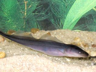
Gymnarchus niloticus, commonly known as the aba, aba aba, frankfish, or African knifefish, is the only species in the family Gymnarchidae within the order Osteoglossiformes. It is found exclusively in swamps and vegetated river edges along the rivers Nile, Niger, Volta, Chad, and Gambia.
The aba has a long and slender body, with no caudal, pelvic, or anal fins. The dorsal fin is elongated, running along the back of the fish towards the blunt, finless, tail, and is the main source of propulsion. It grows up to 1.6 metres (5.2 ft) in length and 19 kilograms (42 lb) in weight.
The aba is nocturnal and has poor vision. Instead, it navigates and hunts smaller fish using a weak electric field similar to that of the related elephantfish. Also like the elephantfishes, it possesses an unusually large brain, which is believed to help it interpret the electrical signals.
Abas lay their eggs in floating nests up to a metre across. The adults continue to guard the young after hatching.
The Gymnarchus niloticus fish can make its tail negatively charged with respect to its head. This produces a symmetrical electric field around its body. Nearby objects distort this field, and the aba can sense the distortion on its skin.

A cenote is a sinkhole with exposed rocky edges containing groundwater. It is typically found in the Yucatán Peninsula and some nearby Caribbean islands. The term is derived from a word used by the low-land Yucatec Maya to refer to any location where groundwater is accessible.
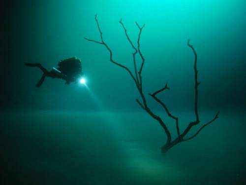
According to Anatoly Beloshchin, a professional photographer, the underwater scenery is amazing. He describes, “We are 30 meters deep, fresh water, then 60 meters deep – salty water and under me I see a river, island and fallen leaves… Actually, the river, which you can see, is a layer of hydrogen sulphide."
The river illusion is due to a phenomenon called halocline, a cline caused by a strong, vertical salinity gradient within a body of water. Because salinity (in concert with temperature) affects the density of seawater, it can play a role in its vertical stratification. Increasing salinity by one kg/m3 results in an increase of seawater density of around 0.7 kg/m.
The Yucatan Peninsula contains a vast coastal aquifer system which is typically density-stratified. The infiltrating meteoric water (i.e., rainwater) floats on top of higher density saline water intruding from the coastal margins. The whole aquifer is therefore an anchialine system (i.e., one that is land-locked, but connected to an ocean). Where a cenote, or the flooded cave it is an opening to, provides deep enough access into the aquifer then the interface between the fresh and saline water may be reached. The density interface between the fresh and saline waters is a halocline, which means a sharp change in salt concentration over a small change in depth. Mixing of the fresh and saline water results in a blurry swirling effect due to refraction between the different density fresh and saline waters. The depth of the halocline is a function of several factors: climate and specifically how much meteoric water recharges the aquifer, hydraulic conductivity of the host rock, distribution and connectivity of existing cave systems and how effective these are at draining water to the coast, and the distance from the coast. In general, the halocline is deeper the further from the coast and in the Yucatan Peninsula this depth is 10 to 20 meters below the water table at the coast, and 50 to 100 meters below the water table in the middle of the peninsula, with saline water underlying the whole of the peninsula.
In Cenote Angelita as you get deeper the water turns from pure to salty; 30 meters deep the water is pure, 60 meters deep it becomes saline. Some meters before you get to the bottom of the cave, you see a river underneath, with trees and leaves floating on some liquid level. However it may seem like a river, it’s not a real river. It’s just a layer of hydrogen sulphide.
Knifefish
The family Notopteridae contains eight species of osteoglossiform (bony-tongued) fishes, commonly known as featherbacks and knifefishes. They are small fishes living in freshwater or brackish environments in Africa and Southeast Asia.
With the denotation of "knifefish", the Notopterids should not be confused with Gymnotiforms, the electric knifefishes. Although their manner of swimming is similar, the two groups are not closely related.
A few of the larger species, especially Chitala chitala, are food fish and occasionally aquarium pets. The name is from Greek noton meaning "back" and pteron meaning "fin".
Featherbacks have slender, elongated, bodies, giving them a knife-like appearance. The caudal fin is small and fused with the anal fin, which runs most of the length of the body. Where present, the dorsal fin is small and narrow, giving rise to the common name of "featherback". The fish swims by holding its body rigid and rippling the anal fin to propel itself forward or backwards.
Notopterids have specialized swim bladders. The organ extends throughout the body and even into the fins in some cases. Although the swim bladder is not highly vascularised, it can absorb oxygen from air and also functions to produce sound by squeezing air through a narrow passage into the pharynx.
At least some species prepare nests and guard the eggs until they hatch.
Giant Sea Foam
Foam swallowed an entire beach and half the nearby buildings, including the local lifeguards' centre, in a freak display of nature at Yamba in New South Wales.
One minute a group of teenage surfers were waiting to catch a wave, the next they were swallowed up in a giant bubble bath. The foam was so light that they could puff it out of their hands and watch it float away.
It stretched for 30 miles out into the Pacific in a phenomenon not seen at the beach for more than three decades.
Scientists explain that the foam is created by impurities in the ocean, such as salts, chemicals, dead plants, decomposed fish and excretions from seaweed.
All are churned up together by powerful currents which cause the water to form bubbles.
These bubbles stick to each other as they are carried below the surface by the current towards the shore.
As a wave starts to form on the surface, the motion of the water causes the bubbles to swirl upwards and, massed together, they become foam.
The foam "surfs" towards shore until the wave "crashes", tossing the foam into the air.
Ommatokoita elongata
Ommatokoita elongata is a parasitic copepod, approximately 5 cm in length (almost 2 inches) with a very specific and truly cringe-worthy preference about where it attaches on to the host. The adult female copepod attaches herself to the shark's eye with an anchoring structure call the bulba, and grazes on the surface of the cornea (see photo, black arrow indicates attachment point), hanging off the eyes of the shark like a grotesque tassle.
There are two possible reasons for the copepod's attachment site. Shark skin is covered in microscopic, teeth-like structures call denticles which can make it difficult for parasites to attach themselves to skin (though some species of parasitic copepods manage). Secondly the eye is considered to be a "immunologically benign environment" for parasites, thus such an attachment is less likely to illicit an immune response.
While the parasite can cause significant damage to the cornea and result in blindness for the host, most sharks seem unaffected by the presence of the parasite and many sharks have the copepod in both eyes, strangely enough. This goes to show when considering the virulence (harmfulness of a parasite to its host) of a parasite, it is worth taking into account the perspective of the host involved - what may seem debilitating to us may not necessarily be the case for the actual organism in question.
Tidal Bore
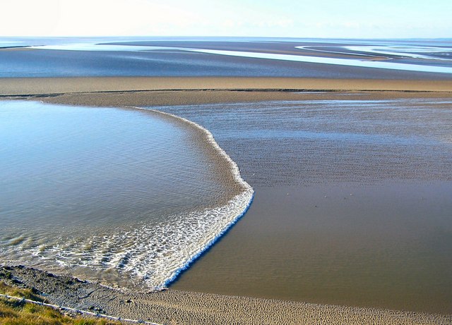
A tidal bore (or simply bore in context, or also aegir, eagre, or eygre) is a tidal phenomenon in which the leading edge of the incoming tide forms a wave (or waves) of water that travel up a river or narrow bay against the direction of the river or bay's current. As such, it is a true tidal wave and not to be confused with a tsunami, which is a large ocean wave traveling primarily on the open ocean.
Bores occur in relatively few locations worldwide, usually in areas with a large tidal range (typically more than 6 metres (20 ft) between high and low water), and where incoming tides are funneled into a shallow, narrowing river or lake via a broad bay. The funnel-like shape not only increases the tidal range, but it can also decrease the duration of the flood tide, down to a point where the flood appears as a sudden increase in the water level. Note the tidal bore takes place during the flood tide and never during the ebb tide.
A tidal bore may take on various forms, ranging from a single breaking wavefront with a roller — somewhat like a hydraulic jump — to ‘undular bores’, comprising a smooth wavefront followed by a train of secondary waves (whelps). Large bores can be particularly very unsafe for shipping,but also present opportunities for river surfing.
Two key features of a tidal bore are the intense turbulence and turbulent mixing generated during the bore propagation, as well as its rumbling noise. The visual observations of tidal bores highlight the turbulent nature of the surging waters. The tidal bore induces a strong turbulent mixing in the estuarine zone, and the effects may be felt along considerable distances. The velocity observations indicate a rapid deceleration of the flow associated with the passage of the bore as well as large velocity fluctuations. A tidal bore creates a powerful roar that combines the sounds caused by the turbulence in the bore front and whelps, entrained air bubbles in the bore roller, sediment erosion beneath the bore front and of the banks, scouring of shoals and bars, and impacts on obstacles. The bore rumble is heard far away because its low frequencies can travel over long distances. The low-frequency sound is a characteristic feature of the advancing roller in which the air bubbles entrapped in the large-scale eddies are acoustically active and play the dominant role in the rumble sound generation.
The word bore derives through Old English from the Old Norse word bára, meaning a wave or swel
Slipper Lobster
Slipper lobsters are a family of decapod crustaceans found in all warm oceans and seas. Despite their name, they are not true lobsters, but are more closely related to spiny lobsters and furry lobsters. Slipper lobsters are instantly recognisable by their enlarged antennae, which project forward from the head as wide plates. All the species are edible, and some, such as the Moreton Bay bug and the "Balmain bug" (Ibacus peronii) are of commercial importance.
Slipper lobsters have six segments in their heads and eight segments in the thorax, which are collectively covered in a thick carapace. The six segments of the abdomen each bear a pair of pleopods, while the thoracic appendages are either walking legs or maxillipeds. The head segments bear various mouthparts and two pairs of antennae. The first antennae, or antennules, are held on a long flexible stalk, and are used for sensing the environment. The second antennae are the slipper lobsters' most conspicuous feature, as they are expanded and flattened into large plates that extend horizontally forward from the animal's head.
There is considerable variation in size among species of slipper lobsters. The Mediterranean species Scyllarus pygmaeus is the smallest, growing to a maximum total length of 55 millimetres (2.2 in), and rarely more than 40 mm (1.6 in). The largest species, Scyllarides haanii, may reach 50 centimetres (20 in) long.
Slipper lobsters are typically bottom dwellers of the continental shelves, found at depths of up to 500 metres (1,600 ft). Slipper lobsters eat a variety of molluscs, including limpets, mussels and oysters, as well as crustaceans, polychaetes and echinoderms. They grow slowly and live to a considerable age. They lack the giant neurones which allow other decapod crustaceans to perform tailflips, and must rely on other means to escape predator attack, such as burial in a substrate and reliance on the heavily armoured exoskeleton.
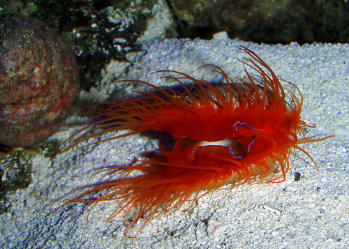
Electric Flame Scallop
The Electric Flame Scallop, also called the Red Electric Flame Scallop or scientifically known as Lima Sp, belongs to the mollusk family known as Limidae which comprises of only bivalve mollusks which are made up of scallops, clams, oysters and mussels that have a shell consisting of two rounded plates called valves joined at one edge by a flexible ligament or hinge.
The Electric Flame Scallop, inhabits the waters of the Indo-Pacific, ranges in size from 1 inch to 3 inches when reaching maturity and is instantly recognizable by its soft parts being a flame red color, with several bright red tentacles protruding from the open valves (shell). What makes this creature even more fascinating is that it seems to create bluish white electricity which can be seen shooting across the mantel like lightning bolts quite visibly in the dark.
While the purpose of the electricity generated by this creature is unknown, it makes a remarkable spectacle for any night dive where even in the darkness; you can see the flicker of bluish electricity bolts flowing through the scallop’s filaments. For underwater photography an electric flame scallop is truly a delight to photograph. During the day, the bio-luminescence isn’t very apparent, which is why electric scallop sightings are more spectacular at night.
The electricity (which is actually a form of bioluminescence) is not known to be harmful to divers or other creatures, and especially since the electric flame scallop is a filter feeder and feeds off on microscopic phytoplankton and bacterioplankton (omnivorous) it is curious why it possesses such a brilliant ability. Marine Biologists suggest that the light generated by the electric scallop attracts plankton to its filament like tentacles helping it feed from a fixed location.
Often the Electric Flame Scallop is confused with its parent species the Flame Scallop or Lima Scabra which is also similar in appearance, with a red fleshy mantle covered with tentacles, except for the absence of the strip of bio-luminescent tissue on its mantle that sends a flash of color back and forth over the mantle. Interestingly enough the Flame Scallop, and it’s sub-species the Electric Flame Scallop are not truly scallops but a form of file-clam.
Pororoca
The pororoca (Portuguese pronunciation: [poɾoˈɾɔkɐ]) is a tidal bore, with waves up to 4 meters high that travel as much as 13 kilometers inland upstream on the Amazon River and adjacent rivers. Its name comes from the indigenous Tupi language, where it translates into "great destructive noise". It occurs at the mouth of the river where river water meets the Atlantic Ocean. The phenomenon is best seen in February and March.
The wave has become popular with surfers. Since 1999, an annual championship has been held in São Domingos do Capim (on the adjacent Guamá River). However, surfing the Pororoca is especially dangerous, as the water contains a significant amount of debris from the shores of the river (often entire trees), in addition to dangerous fauna. In 2003 the Brazilian Picuruta Salazar won the event with a record ride of 12.5 kilometers during 37 minutes. The longest time captured on tape riding the wave is also by Picuruta and it is on 43 minutes.
Along the branches or "caños" in the Orinoco Delta, pororoca is known as macareo, which is also the name of one of these branches.
Tiger Shark
The tiger shark, Galeocerdo cuvier, is a species of requiem shark and the only member of the genus Galeocerdo. Tiger sharks are relatively large macropredators, capable of attaining a length of over 5 m (16 ft). This shark typically reaches maturity at lengths of 2 to 3 m (6.6 to 9.8 ft). It is found in many tropical and temperate oceans, and is especially common around central Pacific islands. Its name derives from the dark stripes down its body, which resemble a tiger's pattern and fade as the shark matures.
The tiger shark is a solitary, mostly night-time hunter. Its diet involves a wide range of prey, including crustaceans, fish, seals, birds, smaller sharks, squid, turtles, sea snakes, and dolphins.
While the tiger shark is considered to be one of the sharks most dangerous to humans, the attack rate is surprisingly low according to researchers. The tiger is second on the list of number of recorded attacks on humans, with the great white shark being first. They often visit shallow reefs, harbours and canals, creating the potential for encounter with humans.
Tiger sharks are considered a near threatened species due to excessive finning and fishing by humans.
The tiger shark is often found close to the coast, in mainly tropical and sub-tropical waters worldwide, though they can reside in temperate waters. Along with the Great White shark, Pacific sleeper shark, Greenland shark and sixgill shark, tiger sharks are among the largest extant sharks. The shark's behavior is primarily nomadic, but is guided by warmer currents, and it stays closer to the equator throughout the colder months. The shark tends to stay in deep waters that line reefs but does move into channels to pursue prey in shallower waters. In the western Pacific Ocean, the shark has been found as far north as Japan and as far south as New Zealand.
Shingle Urchin
The shingle urchin (Colobocentrotus atratus) is a species of sea urchin from the family Echinometridae. It is sometimes commonly referred to as the shingle sea urchin. It is found on wave-swept intertidal shores in the Indo-West Pacific, particularly on the shores of Hawaii. It is usually found on substrata fully exposed to waves and their associated abrasion. They get as big as a soft ball but are rarely found this size. They are usually found in groups. They feed on periwinkle urchins and corralline algae.
Celestial Eye Goldfish
Celestial eye goldfish or Choten gan is a double-tailed breed of fancy goldfish that has a breed-defining pair of telescope eyes which are turned upwards, pupils gazing skyward. When the fry hatch, the eyes of young Celestials are normal but gradually protrude sideways, as in the Telescope eye goldfish, and then turn upwards within a period of six months.
The Celestial is a relatively small variety of goldfish that has a torpedo-shaped body similar to the Bubble Eye. Like the Bubble Eye, the Celestial does not have a dorsal fin. Their paired fins are of the Fantail or Ryukin type. The caudal may be half as long, to as long, as the body. They are most commonly seen with metallic scales colored various shades of orange (called 'red' by fanciers), white, or red and white. Celestials with nacreous scales are known but rarely seen. Despite their limited vision and their lack of a dorsal fin, they are active and agile swimmers. They do require some special attention since, apart from sporting easily damaged upward-oriented eyes, and having limited vision, they are also sensitive to cold water temperatures. They are unable to compete with more vigorous goldfish for food. Sharp ornaments and objects in the aquarium are contraindicated. They are best kept with other limited-vision breeds (i.e the Bubble Eye) or in a tank of their own.
Blood Falls
Blood Falls is an outflow of an iron oxide-tainted plume of saltwater, occurring at the tongue of the Taylor Glacier onto the ice-covered surface of West Lake Bonney in the Taylor Valley of the McMurdo Dry Valleys in Victoria Land, East Antarctica.
Iron-rich hypersaline water sporadically emerges from small fissures in the ice cascades. The saltwater source is a subglacial pool of unknown size overlain by about 400 meters of ice at several kilometers from its tiny outlet at Blood Falls.
The reddish deposit was found in 1911 by the Australian geologist Griffith Taylor, who first explored the valley that bears his name. The Antarctica pioneers first attributed the red color to red algae, but later it was proven to be due only to iron oxides.
This unusual place offers scientists a unique opportunity to study deep subsurface microbial life in extreme conditions without the need to drill deep boreholes in the polar icecap, with the associated contamination risk of a fragile and still-intact environment.
The study of harsh environments on Earth is useful to understand the range of conditions to which life can adapt and to advance assessment of the possibility of life elsewhere in the solar system, in places such as Mars or Europa, an ice-covered moon of Jupiter. Scientists of the NASA Astrobiology Institute speculate that these worlds could contain subglacial liquid water environments favorable to hosting elementary forms of life, which would be better protected at depth from ultraviolet and cosmic radiation than on the surface.
Mass Strandings
The term "mass stranding" refers to events in which groups of distressed cetaceans (whales, dolphins, porpoises) come ashore alive. They can involve anywhere from a few to several hundred animals. Mass strandings regularly occur in several parts of the world (primarily Australia, New Zealand and Cape Cod), yet so far we have no universally accepted, comprehensive explanation for this syndrome.
In many cases, the animals show no obvious signs of health problems other than those resulting from coming ashore. Once a cetacean comes ashore, a cascade of physiological changes occurs, often resulting in shock and death. Because the species typically involved are extremely social, the bonds that hold groups together are perhaps strong enough to supercede the survival instincts of individual animals. Although we don't know what specifically might set off a mass stranding event, we know that once animals start coming ashore, it's extremely difficult to stop the process from continuing and escalating. Affected animals will relentlessly follow one another ashore, as if crippled by widespread panic, even when there is clear access to open water. Gregarious offshore species such as Atlantic white-sided dolphins (Lagenorhynchus acutus) and long-finned pilot whales (Globicephala melaena) are particularly known to mass strand in New England, mainly on Cape Cod.
A staggering 97 dolphins died during a stranding event in January and February of 1998. Carcasses were recovered over a four-week period from over 25 miles of shoreline between Dennis and Wellfleet, on Cape Cod, Massachusetts. Eighty of these were Atlantic white-sided dolphins (Lagenorhynchus acutus) and 16 were common dolphins (Delphinus delphis). Unfortunately, none were healthy enough to be relocated or saved for rehabilitation. A team of biologists, technicians and veterinarians, including many volunteers, responded to the event, providing supportive care, collecting blood samples, and later conducting necropsies and preparing tissue samples.While the exact cause of this stranding is unknown, and may never be known, we believe that a combination of factors, including the new moon (producing unusually extreme tides), and a powerful coastal storm may all have contributed to the event. Another noteworthy aspect of this mass stranding was that it involved two species of dolphins rather than just one. About a year later, in March of 1999, a similar stranding event occurred, again during stormy weather with high winds and unusually extreme tides. This time a total of 54 white-sided dolphins stranded on the Cape Cod coast, from Wellfleet to Eastham. Fortunately, three of these animals were found to be in good physical condition and were transported to a beach in Provincetown, where they were released into open water.
Although mass strandings typically occur during winter months and at times of severe weather, they can occur at any time of year and under any conditions. During the summer of 2000, we responded to a mass stranding of 11 pilot whales on Nantucket Island, on July 4. The weather was clear and calm and the animals showed no obvious underlying health problems.This was the first pilot whale mass stranding to occur in this region since 1992.